

About
Storm update: Open, but one forest track is blocked by fallen trees.
Consisting of 58 hectares, Conrhenny is a growing venue for community involvement, with a 5 hectare Children's Wood located in the heart of the forest. Created as a tree education initiative, the woodland comprises of more than 5,000 native trees, planted over a 10 year period by local primary school children.
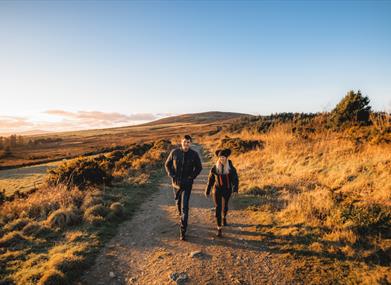
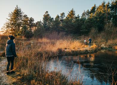
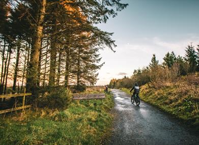
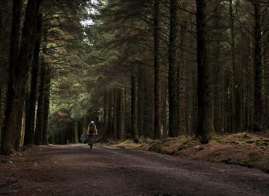
Conrhenny is also a great place for recreation with a good network of paths, a pond and far reaching views over Douglas. It features a number of way-marked mountain bike trails and the chosen venue for the annual 24 hour endurance mountain bike event 'Longest Day Longest Ride'. Conrhenny's particulary flat terrain is also popular with dog walkers, runners and horse riders.
Please remember that forest roads are multi-user routes so share with care and respect other visitors. Please remain on designated routes in order to preserve Conrhenny Community Woodland.
Watch: How to behave on mountain bike trails | Trail etiquette (British Cycling)
The Department of Environment, Food and Agriculture is indebted to a number of local volunteer groups and organisations who have considerably helped with amenity improvements including trail building, path improvements and conservation projects.
Share your experience of Conrhenny using #IOMSTORY
Mountain Bike Trails
1: Drop-In One aka Doris
Grading - Moderate/Blue
This short exciting track follows a downhill slope, along a fairly wide wooden boardwalk. Encounter moderate drops and minor bends, whilst snaking through the forest and the hillside.
2: Drop-In Two aka Riding High
Grading - Difficult/Red
This challenging and varied single track trail caters for the most demanding of riders. Beginning with a steep descent, follow this weaving trail through the forest trees, featuring elevated narrow wooden boardwalks, steady inclines and sharp bends.
3: Garden Path
Grading - Moderate/Blue
Follow this meandering single track trail through the forest, perfect for beginners and experienced riders. Encounter dips, varied and rough terrain, sharp bends, wooden boardwalks and slight inclines.
4: Knight's Trail
Grading - Moderate/Blue
This blue run boasts a number of technical sections including wooden boardwalks, hairpin bends, varied terrain and small obstacles.
5: In-Out Section One
Grading - Moderate/Blue
Fairly straight and short, this simple route diverts off the forest track leading you straight into the woodland. Experience varied terrain and small obstacles and a sharp hairpin turn.
6: In-Out Section Two
Grading - Moderate/Blue
Diverting off the main forest track, this short but simple trail weaves through the forest along a fairly narrow dirt path encountering elevated wooden boardwalk bridges, minor obstacles, bends and slight inclines.
7: Cooper's Cut
Grading - Moderate/Blue
A short piece of single track, linking forest roads. Encounter wooden boardwalks and small obstacles along route.
8: Mr Tickle
Grading - Moderate/Blue
Diverting off the main forest track, this meandering section of single track weaves through the forest, linking forest roads. Encounter small obstacles along route.
9: Doubters Pass
Grading - Moderate/Blue
Diverting off the main forest track, this meandering section of single track weaves through the forest, linking forest roads. Encounter short steep inclines, tight turns and small obstacles along route.
10: Longest Way Round
Grading - Moderate/Blue
Diverting off the main forest track, this meandering section of single track weaves through the forest, linking forest roads. Encounter steep inclines, tight turns and small obstacles along route.
WARNING: Mountain Biking is a potentially hazardous activity carrying significant risk. It should only be undertaken with a full understanding of all inherent risks.
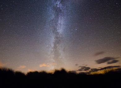
Dark Skies
Conrhenny Plantation offers unspoilt panoramic views over Douglas Bay, and is the perfect spot for budding stargazers, with uninterrupted horizon views from the North East to South to the West. With low light pollution present, Conrhenny Plantation is a fantastic spot to go stargazing.
Conrhenny car park is one of 26 registered Dark Sky Discovery Sites on the Isle of Man. With the help of Interpretation Boards on site, stargazers can fully enjoy the stunning views on offer in the Manx skies.
Advice and Safety:
The stargazing site is a large flat area surrounded by grass verges. Observers need to remain on tarmacked area as there are slopes beyond grass to south and west.
Facilities
Catering
- Picnic Site
Parking & Transport
- On site parking
- Parking (free)
Provider Features
- In countryside
- Outdoor Attraction
Video
- How to behave on mountain bike trails | Trail etiquette