RNF 3: Port St Mary to Port Erin

Type:Walking Route

RNF 3: Port St Mary to Port Erin

Book Tickets Online

About

Ordnance Survey Map : HERE
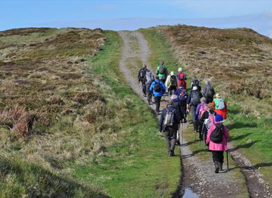
Grading: Moderate
Distance: 11 km / 7 miles

Start: Port St Mary Alfred Pier
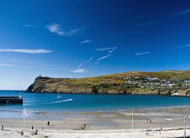
Finish: Port Erin Bay

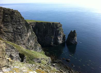
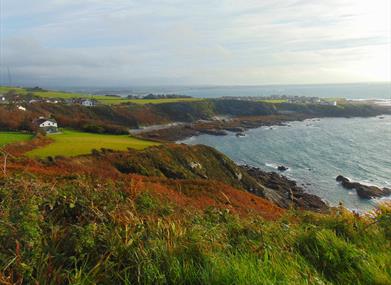
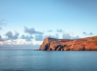
With cinematic views, pass sheer cliffs, historic villages and wonderful wildlife. This walk around the Island's southern coast is a favourite amongst walkers and possibly one of the best coastal walks in the British Isles, which can also be enjoyed at a comfortable pace.

This unforgettable section of the Raad ny Foillan offers tremendous opportunities to see a contrast of scenery as well as marine wildlife. The terrain changes as you leave Port St Mary from grassy footpaths to moorland and cliffs.  A short detour will take you to the rocky Chasms or around the Manx Folk Village of Cregneash. Take a refreshing break at  the half-way point, Cregneash Tea Rooms or The Sound, where you can spot seals sunbathing on the rocky Kitterland, and enjoy parnoramic views of the Calf of Man.

Advice and Safety Information

Sections of the footpath are steep and narrow in places. Take care in extra strong winds. Dogs are not permitted on the section of the footpath between the Sound and Port Erin. Most suitable for older children although the most family friendly section is from The Sound to Port Erin.

Moderate - walks for people with country walking experience and a good level of fitness. The route will include some steep paths and open country. Walking boots and suitable clothing are essential.

Facilities

Accessibility

  • Distance: 5-10 Miles
  • Grade: Moderate
Port St Mary Harbour, Port St Mary

Map & Directions

Public Transport Directions

By Bus: Services 1, 2, 10, 10A, 11, 11A, 12, 12A connect Douglas or Port Erin with Port St Mary.

By Rail: Take the Steam Train starting from Douglas or Port Erin, alight at Port St Mary Station.

What's Nearby

  1. A unique museum that will take you back in time to a period when train travel on the Isle…

    0.69 miles away
  2. Using home-grown produce and eco-friendly methods to make their own sparkling wines,…

    0.95 miles away
  3. Meayll Circle stands near to the summit of Meayll Hill overlooking the south of the…

    1.2 miles away
  1. Settled on an upland plateau overlooking the Calf of Man, Cregneash village was one of…

    1.33 miles away
  2. The Nature Discovery Centre is full of information on its surroundings, the environment…

    3.48 miles away
  3. Discover one of the most preserved medieval castles in Europe.

    3.69 miles away
  4. Be greeted by the secretary of the former home of the Manx Parliament, and take your seat…

    3.7 miles away
  5. Uncover the story of the inventive George Quayle and his most significant surviving…

    3.75 miles away
  6. The beautiful Kirk Malew Church is a traditional Manx church that still retains the…

    3.86 miles away
  7. A wide range of exhibits relating the military and aviation history of the Isle of Man…

    4.17 miles away
  8. Rushen Abbey was gifted by King Olaf I for use as a monastery in 1134. The visitor…

    4.54 miles away
  9. The Silverburn begins its journey above the village of St Marks, passing through…

    4.63 miles away
  10. With views casting over Castletown and Port Erin, stargazers are guaranteed sensational…

    5.59 miles away
  11. The Marine Viewing Site present at Niarbyl Bay, Dalby, provides visitors and residents…

    5.72 miles away
  12. St Marks Country Park is the perfect place for a family day out. Set in approximately 18…

    6.6 miles away
  13. The home of classic bikes in the Isle of Man. A must visit for all genuine motorcycle or…

    7.18 miles away
Previous Next
Download our One Stop Guide Download our one stop guide